Category : Environment Conservation | Location : Tamil Nadu | Posted on 2021-08-02 00:49:57

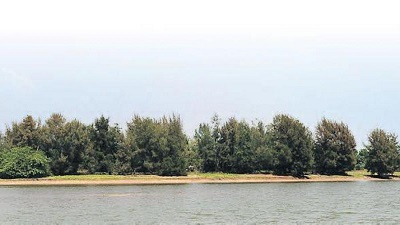
VILLUPURAM: The State government has proposed a modern greenfield fishing harbour with 12,000 tonnes per annum capacity inside the Kaliveli backwaters, South India’s second largest brackish-water lake, in Villupuram district. Biologists say this would disrupt the ecology in what is believed to be the last surviving clean backwaters on the east coast, a home for many wetbird species. Also, the livelihood of small-scale and marginalised fishers in the area is at stake.
The fishing harbour inside the backwaters is proposed to have all supportive amenities like auction halls, landing centres, etc. Fisheries department officials say there is an urgency to develop a harbour due to increased fish catch in Chengalpattu and Villupuram districts, and it would lead to good quality and hygienic fish availability in the markets. But to achieve this, a lot of construction work must be undertaken in the ecologically sensitive area.
The Coastal Regulation Zone (CRZ) clearance application submitted by the fisheries department before the State Coastal Zone Management Authority (TNSCZMA) and reviewed by The New Indian Express, reveals that a navigation channel is proposed to be developed in Kaliveli backwaters to create a permanent approach channel for the fishing vessels.
This would be achieved by clearing the sandbar between the Kaliveli waters and the sea. An area of five hectares of sandbar would be dredged to maintain a water depth of 2.5m lower than the current levels. Besides, a navigation basin is proposed within the backwaters. To prevent sedimentation of the navigation channel, two training walls are planned on the northern and southern sides of the channel measuring 400m and 600m respectively.
Priya Davidar, a conservation biologist, said, “It is an Important Bird Area (IBA), identified by the International Union for Conservation of Nature (IUCN) and the National Wetland Conservation and Management Programme. So, building a harbour inside this region is nothing but a call for disaster. The government can easily build the harbour on the sea front instead of disturbing backwaters, like how the Kasimedu harbour was built.”
The biodiversity-rich waters of Kaliveli lagoon, which is the second largest brackish water body in southern India after Pulicat lake, has been the traditional fishing ground for folk who use non-motorised countryboats. Around 65,000 people, mostly from marginalised communities like Adi Davidar, Scheduled Castes and Scheduled Tribes, are dependent on this lagoon for their livelihood.
Ecological significance of the area is evident as earlier this year, the Villupuram administration issued a first declaration under the Wildlife Protection Act, 1972 to declare Kaliveli wetlands as a bird sanctuary.
M Yuvan, an active member of the Madras Naturalists Society, told Express that Kaliveli wetlands was one of the largest waterfowl congregation sites in Tamil Nadu, and a well-known raptor roosting site for species like the Eastern Imperial Eagle, Greater Spotted Eagle, Red-necked Falcon and several harriers. “The area hosts over 30,000 ducks, 20,000 to 40,000 migratory shorebirds and 20,000 to 50,000 terns in the winter. The Grey-tailed Tattler, a rare migratory wader, has been recorded only here and in the Pulicat across the country,” he said.
Moreover, environmentalists noted that north of the proposed fishing harbour site is the 17th century Alamparai Fort built during the Mugal era at Kadapakkam. Alamparai, a flourishing place of trade, fell into oblivion when the British Army led by Sir Thomas Eyre Coote, captured the fort in 1760 and reduced it to ruins. Now, the State archeology department has taken up works to renovate the fort. Coastal engineers say the training walls of the proposed harbour may trigger erosion near the Alamparai fort.
State archeology department deputy director K Sivanathan said that according to rules, areas 100 metres from the fort is a ‘no development zone’ and areas 100 to 300 metres from the fort is regulated, where only certain kinds of activities are permitted. “They may have to obtain a no objection certificate from the archeology department before commencing works. I will also check on the exact location of the proposed harbour,” he added.
CRZ clearance, EIA report flawed
The fisheries department has committed glaring errors in obtaining Coastal Regulation Zone (CRZ) clearance and in the preparation of Environment Impact Assessment (EIA) report for the project. As per the EIA Notification, 2006, the preparation of Terms of Reference (ToR) is a mandatory prerequisite for the commencement of preparation of the EIA report. The official documents, accessed by Express, reveal that State Environment Impact Assessment Authority issued ToR on October 17, 2020, while EIA report was already completed on June 4 that year, which was in fact used to conduct a public hearing in 2021.
A closer analysis reveals that the Rapid EIA report prepared prior to issuance of ToR was copy pasted and produced as the final EIA report, which is a clear violation of EIA Notification.
Environmentalist and fisherfolk rights activist K Saravanan said that this activity was fraudulent. “The EIA report is riddled with significant errors and is inconsistent with the ToR. The preparation of EIA report before the ToR was issued is sufficient cause in itself to cancel the issuance of CRZ clearance by the State authority.”
When contacted, Environment Secretary Supriya Sahu said she was not aware of the project and would look into the matter.
Source: https://www.newindianexpress.com/states/tamil-nadu/2021/aug/02/proposed-harbour-a-threat-to-kaliveli-ecosystem-2338818.html